by Emma Allington, MCD engineering associate
With their historic economic power, everlasting natural beauty, and surging recreation appeal, Dayton’s rivers are the crowning jewel of the Gem City. However, challenges along these great rivers, such as deteriorating trail infrastructure and dangerously steep levees, continue to restrict their potential. As a key partner in creating the Dayton Riverfront Plan, the Miami Conservancy District (MCD) continues its 108-year legacy of innovative flood protection, intentional conservation, and energized watershed management.
Today, the City of Dayton, and other riverfront communities, are protected from dangerous high water and devastating flooding by the Miami Conservancy District’s (MCD) integrated flood protection system. This unfailing flood protection enables the community to embrace the riverfront, building homes and businesses without fear of loss of property or lives. This also enables the development of riverfront access and recreation amenities all along the river corridor. Without this high level of protection, the Dayton Riverfront Plan would not be possible.
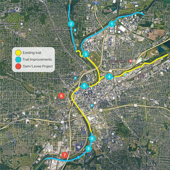
To make the river and trail safer and improve access and amenities, MCD has tackled several new projects in recent years that are also prioritized in the Dayton Riverfront Plan (DRP).
MAP of nine projects increasing river access in Dayton
Constructing new bike trail in Old North Dayton (#1)
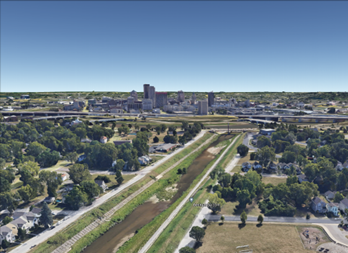
To extend the Great Miami River Recreation Trail (GMRRT) into the Old North Dayton neighborhood along the DRP’s Cultural Corridor, MCD is constructing 3 miles of new paved trail. Constructed in three segments, the new trail is located along the left bank from its current terminus at Island MetroPark to the City of Riverside’s Eintracht clubhouse and hand-carried boat launch. The first segment is already under construction and travels from Helena Street to Keowee Street.

New trail under construction near Keowee Street bridge
The second segment will connect Keowee Street and Heid Avenue, and the third segment will complete the new trail at Eintracht. The first segment was funded through a Department of Commerce Economic Development Authority grant, and the second and third segments will be built with funds awarded by the Miami Valley Regional Planning Commission (MVRPC). MCD is providing matching funds and managing the projects to completion.
Upon completion, this project will also include trail amenities including benches, trash receptacles, and dog waste stations. All three segments will be constructed on land already owned and maintained by MCD as a part of the flood protection infrastructure, further demonstrating how flood protection enables riverfront access and recreation.
Improving the Stillwater River Trail (#2)
The condition of the Stillwater Trail, including a degrading trail surface and a derth of pedestrian amenities, needs to be improved in many ways. Located in the DRP’s Cultural Corridor between the Gayle B. Price bike trail bridge and Wegerzyn Road, the trail needs resurfacing the asphalt and new trail amenities added including swings, benches, trash cans, native prairie plants, and cultural signage. MCD is currently planning the project.
Making the Great Miami River Recreation Trail safer (#3)
To improve safety along the Great Miami River Recreation Trail, MCD identified five street-to-trail intersections that need improvement. These are high-traffic trail and street intersections, but they may lack signals, adequate signage, curb ramps, and compliance with current ADA standards. Within the DRP’s Cultural Corridor, the intersection of the trail and Helena Street near Island MetroPark is one such location. This project will likely include pedestrian-actuated flashing LED warning signs, ADA-compliant curb ramps, pavement striping highlighting the crosswalk, and highly visible trail signage to increase the safety and comfort of trail users. MCD is currently pursuing contractors to begin the design process.
Connecting bike trail into the city (#4)
To connect the Mad River Trail near Tech Town to Webster Street, construction is underway on a new .21-mile-long section of trail in the DRP’s Technology Corridor. MCD is widening the sidewalk along Webster Street and installing a new 12-foot-wide path, a small retaining wall, benches, and trash cans. The Ohio Department of Transportation supported MCD by managing the construction of this project.
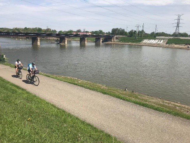
Improving a popular riverfront walking trail (#5)
MCD’s South River Walk is one of the most popular walking paths in the DRP’s Downtown Core. Accessible from the Great Miami River Recreation Trail, the path is a favorite of the adjacent residential and business inhabitants because it is a shady, tree-lined, crushed stone path that stretches from the Main Street bridge along the Great Miami River to the I-75 bridge behind the Dayton YMCA. The improvements include resurfacing the stone path, upgrading lighting to LED, and installing new pedestrian amenities including swings, picnic tables, trash cans, way-funding signs, and dog stations. MCD is currently designing the improvements.

On the South River Walk, looking downstream towards the Dayton Art Institute
Strengthening levees and improving access to Wolf Creek (#6)
A plan for redesigning the mouth of Wolf Creek with more gradual slopes will strengthen MCD’s levee, mitigate danger and difficulty associated with maintaining steep slopes, improve the look of the area, and make it easier to access the river for recreation.
The project would stretch from Edwin C. Moses Boulevard to Orth Avenue on the left bank and from Sweetman Street to North Broadway Street on the right bank. The project will benefit both these residents and MCD staff who maintain the area by laying back the levee, a process that extends and shallows the levee slope. MCD and its partners, City of Dayton and Five Rivers MetroParks, are exploring funding options in a preliminary planning phase.
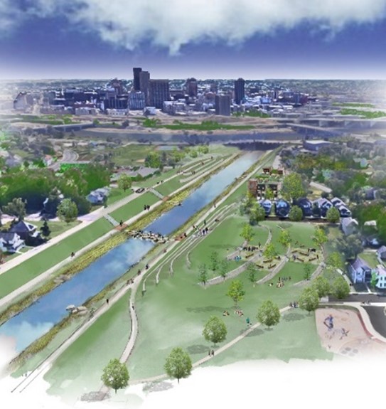
Existing river corridor (L) and concept design (R)
Removed a dangerous hazard on the Great Miami River (#7)
The river was made safer along the DRP’s Education Corridor when MCD removed a low dam in 2018. Located near the University of Dayton and Carillon Park, the low dam was referred to as the “Tait Station” dam. It was originally used as part of a DP&L power plant cooling system but was transferred to MCD many years ago to manage as a recreation amenity. The pooled water behind the dam provided boating access for many years.
By 2018 the dam was in dire need of repairs estimated at $7 million. The cost of removing the dam was considerably less at just $1.7 million. Low dams are also known as a safety hazard to paddlers who are required to portage. Removing the dam significantly improved the river’s ecosystem to support wildlife. The funding to remove the dam was provided by the Ohio Department of Transportation and was matched with funds from MCD.

Before removal (L) After removal (R)
Installing a Storybook Trail Along the Great Miami River Recreation Trail (#8)
A new storybook trail featuring a children’s book about water will be installed along the Great Miami River Recreation Trail just north of Carillon Boulevard in the DRP’s Education Corridor. The 12 signs of the trail feature pages from Into the River, a book written and published by students from the University of Dayton’s Rivers Institute at the Fitz Center for Leadership and Community. This book, created with input and art from local elementary students, was strategically written to educate children about the importance of water and to address literacy rates in the city. The signs have been assembled, and the next step is installation.
Widening the Great Miami River Recreation Trail (#9)
Between East River Road and Stewart Street Bridge, the trail along DRP’s Cultural Corridor faces multiple issues that restrict its ability to serve its many trail users. There are safety concerns when cars park on the shoulder of the road, the narrow width of the trail, large cracks in the pavement, and poor drainage. The scope of this project includes reconstructing and widening the trail, as well as improving drainage, trail access, parking, lighting, and other trail amenities. MCD is finalizing the project schedule with the Ohio Department of Transportation, and the next milestone will be hiring a design consultant.
Keeping the Promise of Unfailing Flood Protection
To ensure the Dayton riverfront stays protected from high water, MCD is also tackling a comprehensive capital improvement plan for the entire integrated flood protection system.
While funds used for recreation projects are not mingled with dollars used for flood protection goals, there continue to be overlapping benefits. Investment in dams, levees, and other integrated flood projection infrastructure ensures that riverfront cities are safe from raging rivers, and recovery from devastating floods does not replace the priority of communities to utilize their riverfronts for recreation.
To learn more about MCD and its mission to protect, preserve, and promote, visit www.MCDwater.org
A shortened version of this story was first published here: Dayton Riverfront Master Plan blog
